Click on any image to expand it. These pages are currently updated by cron job from /ftp_isass5/sxt_co/idl/go_quick.pro. The weekly GOES plot and the line drawings show the time of creation, JST (UT+9 h). Beware of old versions kept in your Netscape cache!
SXT is now running this sequence table.
We now have e-mail aliases and sample images for alert messages.
| On-line data summary for current week. Blue ticks denote PFI's, red ticks FFI's, purple ticks flare mode. |
|

| The current GOES data in the same format (last 24 hours only). |
| Stray light. Derived from the standard stray-light monitoring images, the value normally oscillates between two levels; this display uses an empirical factor to plot the two levels on the same scale. |

|
| DPE values for Dagwood PFI (non-flare) exposures, as a guide to the current exposure times. Subtract two to get good settings for thin Al, add 8 for thick Al, add 10 for Be. |

|

| Current visibility limits of patrol image, displayed on latest SFD. Active regions outside the patrol region may not be tracked by ARS. |
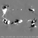
| Locations of SFC database (since the 1997 rupture) relative to the current locations of the HXT fiducial zones. |

|
|
The latest SFD image and PFI coverage map: Table of the 20 Most Recent 1/2 Resolution SFD Images. Or, select individual SFD images from the following list: 0 1 2 3 4 5 6 7 8 9 10 11 12 13 14 15 16 17 18 19 |

|

|

| Times of today's KSC contacts, from SHOW_CONTACTS. Note that the red line marked "NOW" is plotted for the time this page was created, not the time that you are viewing it! |

| The PLOT_TRAV database for /OPS at ISAS. The times listed are from 3 months ago to 9 months from now. |